ModInfo:
NorootorLuckyPatcherorGooglePlayModdedrequired
Disabled/RemovedunwantedPermissions+Receivers+Providers+Services
OptimizedandzipalignedgraphicsandCleanedresourcesforfastload
GoogleMapsLocationsworks
GooglePlayStoreinstallpackagecheckdisabled
Debugcoderemoved
Removedefault.sourcetagsnameofthecorrespondingjavafiles
Analytics/Crashlytics/Firebasedisabled
CPUs:armeabi-v7a,arm64-v8a,x86,x86_64
ScreenDPIs:160dpi,240dpi,320dpi,480dpi,640dpi
Originalpackagesignaturechanged
ReleasebyBalatan.
PeakFinder equips users with extensive topographical data and insights regarding both towering peaks and smaller mountains globally. Designed for enthusiasts of terrain exploration and mountain climbing, this application has effectively compiled and updated nearly all relevant information on mountains and mountain ranges worldwide. With vital details such as elevation, topographical features, and geographical locations, PeakFinder has established itself as a reliable resource for climbers, whether they are novices or seasoned professionals.
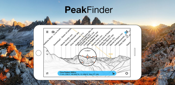
The PeakFinder app allows users to not just monitor nearby mountains but also search for peaks in distant regions. This capability is part of the “Viewpoint selection” feature within the app. Users can conveniently choose from several options:
My marks: This menu includes locations you have previously marked during trips or searches. Generally, these markers represent mountain positions rather than specific site coordinates.
Peak directory: An organized list of global mountains sorted by height, allowing users to discover and visualize summits from far-flung areas.
Maps (Online): Utilize the integrated map function to pinpoint a specific locale and view what mountains are present in that vicinity.
Enter coordinates: Input longitude and latitude coordinates for more precise observations of a chosen location.
• Operates offline and functions globally without limitation
• Contains an impressive database of over 1,000,000 mountain names
• Superimposes Camera Images with panoramic illustrations *
• Provides real-time rendering of surrounding sceneries up to a distance of 300 km/200 miles
• Features a digital telescope functionality for identifying lesser-known peaks
• 'Show me' feature highlights visible peaks in your viewing area
• Select viewpoints through GPS, consult the peak directory, or utilize an online map tool
• Option to mark preferred mountains and significant locations
• Simulate flying from one peak to another vertically and laterally
• Displays solar and lunar cycles, including rise and set times for celestial bodies
• Employs compass tools and motion sensors for enhanced navigation
• Daily updates ensure the peak directory remains accurate and current
• No ongoing subscription fees; a one-time payment provides full access
• Completely ad-free experience for uninterrupted usage
Android
(Your comment needs to be reviewed before it can be displayed) Reply [] Floor Cancel Reply